Town of Kill Devil Hills
  • Spanish
  • Chinese
  • Tagalog
  • Vietnamese
  • French
  • Korean
  • German
  • Arabic
  • Russian
  • Italian
  • Portuguese
  • Hindi
  • Polish
  • Japanese
  • Urdu
  • Persian
  • Gujarati
  • Greek
  • Bengali
  • Panjabi
  • Telugu
  • Armenian
  • Hebrew
  • Hmong
  • Haitian Creole
  • Align Left
  • Align Center
  • Align Right
  • Align Justify
  • Default
  • Lower Alpha
  • Lower Greek
  • Lower Roman
  • Upper Alpha
  • Upper Roman
  • Default
  • Circle
  • Disc
  • Square
  • Normal

  • Headline

  • Subhead 1

  • Subhead 2

  • Hyperlink

September 22, 2023

Weather Update and Safety

View the latest weather briefing from the National Weather Service.

(Disclaimer: The information contained in the NWS briefings are time-sensitive. Note expiration time on briefing.)

The National Hurricane Center anticipates Tropical Storm Ophelia forming later today (9/22/23) and making landfall along the North Carolina coast tomorrow (9/23/23).  Dare County remains under a Tropical Storm Warning, Storm Surge Watch, High Surf Advisory and Flood Watch.

WATCH conditions are possible.  WARNING conditions are expected.

Storm Watch vs. Warning Tropical storm WATCH conditions are possible.  Tropical storm WARNING conditions are expected.
  • Spanish
  • Chinese
  • Tagalog
  • Vietnamese
  • French
  • Korean
  • German
  • Arabic
  • Russian
  • Italian
  • Portuguese
  • Hindi
  • Polish
  • Japanese
  • Urdu
  • Persian
  • Gujarati
  • Greek
  • Bengali
  • Panjabi
  • Telugu
  • Armenian
  • Hebrew
  • Hmong
  • Haitian Creole
  • Align Left
  • Align Center
  • Align Right
  • Align Justify
  • Default
  • Lower Alpha
  • Lower Greek
  • Lower Roman
  • Upper Alpha
  • Upper Roman
  • Default
  • Circle
  • Disc
  • Square
  • Normal

  • Headline

  • Subhead 1

  • Subhead 2

  • Hyperlink

Impacts to our area:

Tropical storm-force winds are expected later today and will persist until late Saturday night. The easterly wind flow is expected to peak sometime in the late afternoon on Saturday, and into the evening the storm is expected to move north and the wind will shift to the south and southwest. 

As the shift occurs, wind speed will also drop, which could lead to a quick return of sound water that was pushed west. Should this occur, the potential for soundside flooding impacts will increase. To sign up to receive alerts if water levels in your area begin to rise due to storm surge, visit www.FIMAN.NC.gov and select the flood gauge(s) located in the waterway you’d like to monitor in real time.

  • Life-threatening rip currents and large surf with waves heights of 7-10 feet in the surf zone will result in dangerous conditions along all Dare County beaches continuing into the weekend.
  • The easterly wind will bring potential for life-threatening storm surge of 2-4 feet above ground along the oceanfront, while pushing sound waters to the west. With the current forecast, the potential for rising water levels should be anticipated at all locations within Dare County that are susceptible to wind-driven flood impacts. *Details on timing can be found on the National Weather Service Newport/Morehead City, N.C. website by entering your location in the upper left corner and then reviewing the wind direction and intensity on the “Hourly Weather Forecast” found at the bottom right under “Additional Resources.” 
  • Increasing winds that should peak at 45-55 mph with gusts of up to 70 mph are expected to begin on Friday, September 22, 2023 and continue through the afternoon of Saturday, September 23, 2023. Actions should be taken now to secure loose property to keep it from becoming a projectile hazard.
  • 3-6 inches of flooding rain with locally higher amounts is forecast, as well as rainfall that could lead to flash flooding and standing water on roadways that may impact travel.
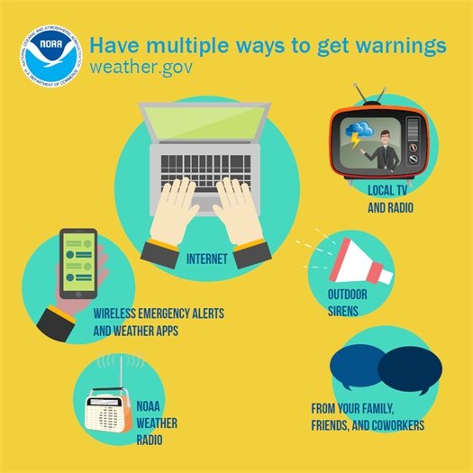
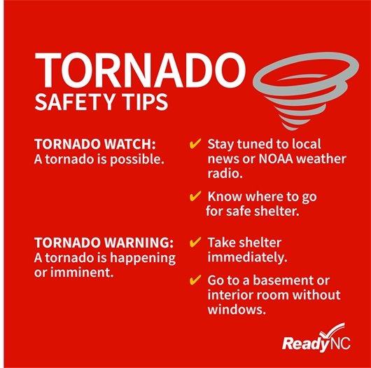
  • Potential tornado activity is also possible. Be sure to have multiple ways to receive weather alerts, especially at night.
  • Travel impacts will occur as the combination of high winds, heavy rain and potential overwash bring hazardous road conditions. Travel on N.C. Highway 12 may be impacted by ocean overwash at vulnerable locations, especially during high tide. Travel on secondary roads throughout Dare County that routinely flood during wind-driven events may also become impassable and hazardous.
  • Travel on Saturday, September 23, 2023 should be avoided. Those who are planning to travel to Dare County tomorrow should consider waiting until Sunday, September 24, 2023, when conditions are forecast to improve. Impacts may be seen on roads throughout Dare County—not just on Hatteras Island—from the combination of strong winds, flooding rain and potential soundside surge.
  • Residents and visitors who are located along the oceanfront and have no protective dune should consider relocating and taking action now to protect property.

Residents and visitors who are on the soundside should be ready to take action should the east wind drive water to the west. The potential rapid return of water on Saturday afternoon and into the evening could put property at risk of being flooded. Consider moving vehicles to higher ground, just in case.

  • Spanish
  • Chinese
  • Tagalog
  • Vietnamese
  • French
  • Korean
  • German
  • Arabic
  • Russian
  • Italian
  • Portuguese
  • Hindi
  • Polish
  • Japanese
  • Urdu
  • Persian
  • Gujarati
  • Greek
  • Bengali
  • Panjabi
  • Telugu
  • Armenian
  • Hebrew
  • Hmong
  • Haitian Creole
  • Align Left
  • Align Center
  • Align Right
  • Align Justify
  • Default
  • Lower Alpha
  • Lower Greek
  • Lower Roman
  • Upper Alpha
  • Upper Roman
  • Default
  • Circle
  • Disc
  • Square
  • Normal

  • Headline

  • Subhead 1

  • Subhead 2

  • Hyperlink

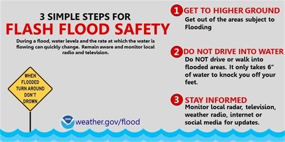
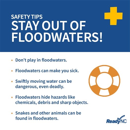
Flood Safety 

During a flood, water levels and the rate at which water is flowing can quickly change.

You are safest by staying indoors, or seeking higher ground if shelter isn’t available. If you’re stuck outside when a flash flood occurs, do not attempt to cross flood waters by vehicle or on foot.

  • Turn around, don't drown!
  • Do not drive around barricades.
  • If possible, delay travel until conditions improve.
Flash flood safety info
  • Spanish
  • Chinese
  • Tagalog
  • Vietnamese
  • French
  • Korean
  • German
  • Arabic
  • Russian
  • Italian
  • Portuguese
  • Hindi
  • Polish
  • Japanese
  • Urdu
  • Persian
  • Gujarati
  • Greek
  • Bengali
  • Panjabi
  • Telugu
  • Armenian
  • Hebrew
  • Hmong
  • Haitian Creole
  • Align Left
  • Align Center
  • Align Right
  • Align Justify
  • Default
  • Lower Alpha
  • Lower Greek
  • Lower Roman
  • Upper Alpha
  • Upper Roman
  • Default
  • Circle
  • Disc
  • Square
  • Normal

  • Headline

  • Subhead 1

  • Subhead 2

  • Hyperlink

For current road conditions from NCDOT, visit drivenc.gov or follow NCDOT on Twitter or Facebook.  

Stay out of flood waters
  • Spanish
  • Chinese
  • Tagalog
  • Vietnamese
  • French
  • Korean
  • German
  • Arabic
  • Russian
  • Italian
  • Portuguese
  • Hindi
  • Polish
  • Japanese
  • Urdu
  • Persian
  • Gujarati
  • Greek
  • Bengali
  • Panjabi
  • Telugu
  • Armenian
  • Hebrew
  • Hmong
  • Haitian Creole
  • Align Left
  • Align Center
  • Align Right
  • Align Justify
  • Default
  • Lower Alpha
  • Lower Greek
  • Lower Roman
  • Upper Alpha
  • Upper Roman
  • Default
  • Circle
  • Disc
  • Square
  • Normal

  • Headline

  • Subhead 1

  • Subhead 2

  • Hyperlink
BEACH REMINDER:  Respect the flags, if red flags are flying you should not be swimming! Current ocean conditions have made ocean swimming unsafe for even the most experienced swimmers. Don't risk your life or someone else's. Stay safe, stay out of the ocean!

BEACH REMINDER:  Respect the flags, if red flags are flying you should not be swimming! Current ocean conditions have made ocean swimming unsafe for even the most experienced swimmers. Don't risk your life or someone else's. Stay safe, stay out of the ocean! 

Be sure you have multiple ways to

 receive severe weather alerts.

Sign up to receive emergency alert notifications from Dare County and Kill Devil Hills.

Have multiple ways to get weather/emergency warnings
Tornado Safety tips
  • Spanish
  • Chinese
  • Tagalog
  • Vietnamese
  • French
  • Korean
  • German
  • Arabic
  • Russian
  • Italian
  • Portuguese
  • Hindi
  • Polish
  • Japanese
  • Urdu
  • Persian
  • Gujarati
  • Greek
  • Bengali
  • Panjabi
  • Telugu
  • Armenian
  • Hebrew
  • Hmong
  • Haitian Creole
  • Align Left
  • Align Center
  • Align Right
  • Align Justify
  • Default
  • Lower Alpha
  • Lower Greek
  • Lower Roman
  • Upper Alpha
  • Upper Roman
  • Default
  • Circle
  • Disc
  • Square
  • Normal

  • Headline

  • Subhead 1

  • Subhead 2

  • Hyperlink


Notice of Meeting

Board of Adjustment

On Tuesday, September 26, 2023, at 5:00 p.m. the Kill Devil Hills  Board of Adjustment will hold a meeting in the Meeting Room at the Administration Building, 102 Town Hall Drive, Kill Devil Hills. View meeting agenda

Share on Facebook
Share on Twitter
Share via Email

Copyright © 2023 Kill Devil Hills. All Rights Reserved.
102 Town Hall Drive Kill Devil Hills, NC 27948; Phone: 252-449-5300; Email: rachel@kdhnc.com

Powered by
CivicSend - A product of CivicPlus