September 21, 2023 Tropical Storm Warning, Storm Surge Watch & High Surf Advisory in Effect for Dare County
(Disclaimer: The information contained in the NWS briefings are time-sensitive. Note expiration time on briefing.) The National Hurricane Center has issued a Tropical Storm Warning and a Storm Surge Watch for all areas of Dare County due to the expected impacts from an area of low pressure that is expected to develop off the southeastern coast of the United States later today (Thursday, September 21, 2023). This developing system—which is currently identified as POTENTIAL TROPICAL CYCLONE SIXTEEN by the National Hurricane Center and which could become Tropical Storm Ophelia—will likely bring tropical storm-force winds, storm surge, heavy rain and high surf to Dare County beginning on Friday, September 22, 2023 and continuing into the weekend. A Tropical Storm Warning indicates that tropical storm conditions—including sustained winds of 39 mph to 73 mph—are expected within 36 hours or less. A Storm Surge Watch indicates the possibility of life-threatening inundation of water within 48 hours. A High Surf Advisory that was issued by the National Weather Service office in Newport/Morehead City, N.C. at 3:50 a.m. today (Thursday, September 21, 2023) will remain in effect until 5 p.m. on Saturday, September 23, 2023. Residents and visitors throughout Dare County should expect these impacts: - Life-threatening rip currents and large surf with waves heights of 7-10 feet in the surf zone will result in dangerous conditions along all Dare County beaches beginning today (Thursday, September 21, 2023) and continuing into the weekend.
- Between 2-4 feet of above-ground storm surge inundation is possible along the oceanfront and soundside. Specific locations and impacts will be driven by wind strength and direction. With the current forecast, the potential for rising water levels should be anticipated at all locations within Dare County that are susceptible to wind-driven flood impacts. *Details on timing can be found on the National Weather Service Newport/Morehead City, N.C. website by entering your location in the upper left corner and then reviewing the wind direction and intensity on the “Hourly Weather Forecast” found at the bottom right under “Additional Resources.”
- Increasing winds that should peak at 45-55 mph with gusts of up to 70 mph are expected to begin on the evening of Friday, September 22, 2023 and continue through the afternoon of Saturday, September 23, 2023. Actions should be taken now to secure loose property to keep it from becoming a projectile hazard.
- 3-6 inches of flooding rain with locally higher amounts is forecast, as well as rainfall that could lead to flash flooding and standing water on roadways that may impact travel.
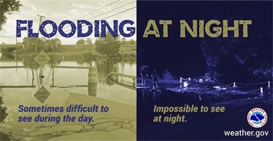
- Potential tornado activity is also possible. Be sure to have multiple ways to receive weather alerts, especially at night.
- Travel on N.C. Highway 12 may be impacted by ocean overwash at vulnerable locations, especially during high tide. Travel on secondary roads throughout Dare County that routinely flood during wind-driven events may also become impassable and hazardous.
Actions should be taken now to protect vehicles and property that is parked or stored in areas that are susceptible to wind-driven flooding countywide. Those who are located in vulnerable oceanfront homes that have the potential to be surrounded by ocean water due to there being no existing dune structure should relocate. |
|
|
|
BEACH REMINDER: Respect the flags, if red flags are flying you should not be swimming! Current ocean conditions have made ocean swimming unsafe for even the most experienced swimmers. Don't risk your life or someone else's. Stay safe, stay out of the ocean!
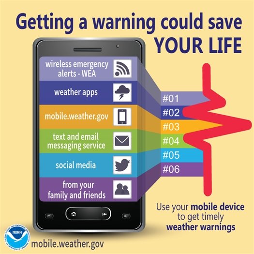
It’s important for your safety to have multiple ways to receive warnings. This will help you and your family prepare and know when to act. There is potential that our area will be impacted by tornadoes. Tornadoes that occur during the night are particularly dangerous. Have multiple ways to receive warnings, and at least one that can wake you up!
|
|
|
|
|
|
To sign up to receive alerts if water levels in your area begin to rise due to storm surge, visit www.FIMAN.NC.gov and select the flood gauge(s) located in the waterway you’d like to monitor in real time.
|
|
|
|
Temporary Closure of
Disc Golf Course on 9/21The Casey R. Logan Disc Golf Course will be temporarily closed to the public today, September 21, 2023, from the hours of 5:00 - 9:00 p.m. while the First Flight and Manteo High School’s Marlin Bowl football game is taking place.
|
|
|
|
Temporary Closure of
Open Play Field at Meekins FieldThe open play field at Meekins Park will be temporarily closed to the public beginning on Monday, October 2, 2023, until further notice, while seeding is occurring.
|
|
|
|