Town of Kill Devil Hills
  • Spanish
  • Chinese
  • Tagalog
  • Vietnamese
  • French
  • Korean
  • German
  • Arabic
  • Russian
  • Italian
  • Portuguese
  • Hindi
  • Polish
  • Japanese
  • Urdu
  • Persian
  • Gujarati
  • Greek
  • Bengali
  • Panjabi
  • Telugu
  • Armenian
  • Hebrew
  • Hmong
  • Haitian Creole
  • Align Left
  • Align Center
  • Align Right
  • Align Justify
  • Default
  • Lower Alpha
  • Lower Greek
  • Lower Roman
  • Upper Alpha
  • Upper Roman
  • Default
  • Circle
  • Disc
  • Square
  • Normal

  • Headline

  • Subhead 1

  • Subhead 2

  • Hyperlink

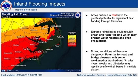
August 30, 2023,  6:00 p.m.

Coastal Flood Warning Now 

in Effect for Dare County


View the latest weather briefing from the National Weather Service.

(Disclaimer: The information contained in the NWS briefings are time-sensitive. Note expiration time on briefing.)

The National Weather Service in Newport/Morehead City, N.C. has issued a Coastal Flood Warning for all areas of Dare County. 

The Tropical Storm Warning that was issued by the National Hurricane Center on the morning of August 30, 2023, remains in effect. A Tropical Storm Warning indicates that tropical storm conditions—including sustained winds of 39 mph to 73 mph—are expected within 36 hours or less.

Please continue to monitor the US National Weather Service Newport/Morehead City NC forecast for our area. Rainfall amounts and the threat of flooding have increased. Tornados are possible.  It’s important for your safety to have multiple ways to receive warnings. Be sure to have at least one device that will wake you up at night. Sign up for emergency alerts at OBXalerts.com
  • Spanish
  • Chinese
  • Tagalog
  • Vietnamese
  • French
  • Korean
  • German
  • Arabic
  • Russian
  • Italian
  • Portuguese
  • Hindi
  • Polish
  • Japanese
  • Urdu
  • Persian
  • Gujarati
  • Greek
  • Bengali
  • Panjabi
  • Telugu
  • Armenian
  • Hebrew
  • Hmong
  • Haitian Creole
  • Align Left
  • Align Center
  • Align Right
  • Align Justify
  • Default
  • Lower Alpha
  • Lower Greek
  • Lower Roman
  • Upper Alpha
  • Upper Roman
  • Default
  • Circle
  • Disc
  • Square
  • Normal

  • Headline

  • Subhead 1

  • Subhead 2

  • Hyperlink

Strong winds and rough surf will also result in an increased risk of strong rip currents. Even the most experienced swimmers are advised to stay out of the ocean due to the dangerous surf conditions that are occurring along all Dare County beaches. Don't risk your life or someone else's. Stay safe, stay out of the ocean! 

Residents and visitors throughout Dare County should expect:

  • Increasing winds that should peak at 35-45 mph with gusts of up to 55 mph on Thursday, August 31, 2023 and diminish slowly on Friday, September 1, 2023. Actions should be taken now to secure loose property to keep it from becoming a projectile hazard.
  • 4-10 inches of rain, with amounts as high as 15 inches in some areas, could lead to flash flooding and standing water on roadways that may impact travel.
  • Potential tornado activity. Always have multiple ways to receive weather alerts, especially at night.

Travel on N.C. Highway 12 on Hatteras Island may be impacted by ocean overwash, especially during high tides. Those in vulnerable oceanfront homes that have the potential to be surrounded by ocean water due to no existing dune structure should relocate. Actions should also be taken to protect vehicles and property parked or stored in areas that may flood.

Information on flooding warnings and emergencies
Turn around, don't drown! Don't drive through roads with flooded waters.
  • Spanish
  • Chinese
  • Tagalog
  • Vietnamese
  • French
  • Korean
  • German
  • Arabic
  • Russian
  • Italian
  • Portuguese
  • Hindi
  • Polish
  • Japanese
  • Urdu
  • Persian
  • Gujarati
  • Greek
  • Bengali
  • Panjabi
  • Telugu
  • Armenian
  • Hebrew
  • Hmong
  • Haitian Creole
  • Align Left
  • Align Center
  • Align Right
  • Align Justify
  • Default
  • Lower Alpha
  • Lower Greek
  • Lower Roman
  • Upper Alpha
  • Upper Roman
  • Default
  • Circle
  • Disc
  • Square
  • Normal

  • Headline

  • Subhead 1

  • Subhead 2

  • Hyperlink

Turn around, don't drown! For current road conditions from NCDOT, visit drivenc.gov or follow NCDOT on Twitter or Facebook. 


Sign up to receive emergency alerts from Dare County & KDH

It’s important for your safety to have multiple ways to receive warnings. This will help you and your family prepare and know when to act.  

Some storms, or other events, may occur when you are sleeping. Have at least one device that will wake you up at night.

Sign up to receive emergency alerts It’s important for your safety to have multiple ways to receive warnings. This will help you and your family prepare and know when to act.   Some storms, or other events, may occur when you are sleeping. Have at least one device that will wake you up at night.
information on tornado safety
Share on Facebook
Share on Twitter
Share via Email

Copyright © 2023 Kill Devil Hills. All Rights Reserved.
102 Town Hall Drive Kill Devil Hills, NC 27948; Phone: 252-449-5300; Email: rachel@kdhnc.com

Powered by
CivicSend - A product of CivicPlus