Town of Kill Devil Hills
  • Spanish
  • Chinese
  • Tagalog
  • Vietnamese
  • French
  • Korean
  • German
  • Arabic
  • Russian
  • Italian
  • Portuguese
  • Hindi
  • Polish
  • Japanese
  • Urdu
  • Persian
  • Gujarati
  • Greek
  • Bengali
  • Panjabi
  • Telugu
  • Armenian
  • Hebrew
  • Hmong
  • Haitian Creole
  • Align Left
  • Align Center
  • Align Right
  • Align Justify
  • Default
  • Lower Alpha
  • Lower Greek
  • Lower Roman
  • Upper Alpha
  • Upper Roman
  • Default
  • Circle
  • Disc
  • Square
  • Normal

  • Headline

  • Subhead 1

  • Subhead 2

  • Hyperlink

August 29, 2023

Tropical Storm Watch Now 

in Effect for Dare County


View the latest weather briefing from the National Weather Service.

(Disclaimer: The information contained in the NWS briefings are time-sensitive. Note expiration time on briefing.)

The National Hurricane Center has issued a Tropical Storm Watch for Dare County due to expected impacts from Hurricane Idalia, which is forecast to move off the East Coast into the Atlantic Ocean after making landfall in Florida as a major hurricane on Wednesday, August 30, 2023. 

A Tropical Storm Watch indicates that tropical storm conditions—including sustained winds of 39 mph to 73 mph—are possible within 48 hours.

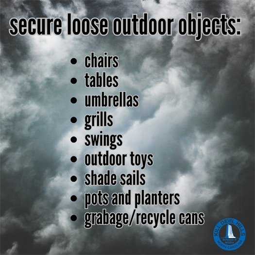
As of Tuesday, August 29, 2023, the National Weather Service is forecasting significant rain, high winds and minor storm surge inundation (up to 2 feet above ground in low-lying areas) for our area. There is also a potential for tornadoes, ocean overwash and moderate beach erosion. Based on the current forecast track for Hurricane Idalia, most of these conditions will impact Hatteras Island. 

For those who are staying or living at an oceanfront or soundfront location, be prepared to protect your property. Storm surge can quickly inundate places where vehicles and other personal property are normally parked or stored. Take the time now to find a higher spot for your vehicles and property to keep them from being damaged.     

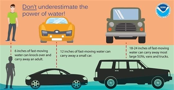
According to the National Weather Service at Newport/Morehead City, N.C., an average of 4-8 inches of rainfall is expected with locally higher amounts of rainfall possible across the area. Rainfall from this storm may lead to flash flooding which could impact travel. Always remember to turn around, don't drown should you encounter flooded streets.  

Impacts from Hurricane Idalia are anticipated to begin late Wednesday, August 30, 2023, into Thursday, August 31, 2023, and are expected to persist through Friday, September 1, 2023. 

Strong winds and rough surf will also result in an increased risk of strong rip currents. Even the most experienced swimmers are advised to stay out of the ocean due to the dangerous surf conditions that are occurring and will persist into the holiday weekend at all Dare County beaches.

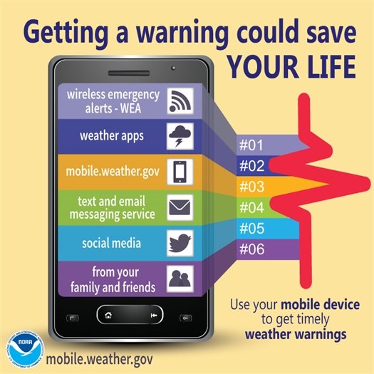
Residents and visitors are encouraged to monitor updated weather forecasts from the National Hurricane Center and our local National Weather Service office. 

It’s important for your safety to have multiple ways to receive warnings. This will help you and your family prepare and know when to act.   Some storms, or other events, may occur when you are sleeping. Have at least one device that will wake you up at night.
Respect the flags, if red flags are flying you should not be swimming! Don't risk your life or someone else's. Stay safe, stay out of the ocean!


BEACH REMINDER:  Respect the flags, if red flags are flying you should not be swimming! Don't risk your life or someone else's. Stay safe, stay out of the ocean!

As you are making storm preparations, make sure to secure all loose outdoor items. See the below list for an idea of what should be secured.

As you are making storm preparations, make sure to secure all loose outdoor items.

Turn Around, Don't Drown!

When flooding is happening, avoid walking or driving through floodwaters. Turn around, don't drown! 

For current road conditions from NCDOT, visit drivenc.gov or follow NCDOT on Twitter or Facebook. 

Did you know only six inches of flood water can move a car and flood water can contain dangerous debris and bacteria? Remember: When flooding is happening, avoid walking or driving through floodwaters. Turn around, don't drown! More tips: ready.gov/floods
Share on Facebook
Share on Twitter
Share via Email

Copyright © 2023 Kill Devil Hills. All Rights Reserved.
102 Town Hall Drive Kill Devil Hills, NC 27948; Phone: 252-449-5300; Email: rachel@kdhnc.com

Powered by
CivicSend - A product of CivicPlus